Showing posts with label Landscape Architecture. Show all posts

Friday, May 5, 2017

Understanding What Makes Plants Happy


A dense carpet of woodland perennials. Thomas Rainer, a landscape architect, calls plants “social creatures” that thrive in particular networks. Credit Mark Baldwin
 Thomas Rainer and I have both been doing the botanical thing for decades; we know, and use, many of the same plants — and even much of the same horticultural vocabulary. But what he and I see when we look at a butterfly weed or a coneflower, or what we mean when we say familiar words like “layering” or “ground cover,” is surprisingly not synonymous.

It turns out I’ve been missing what the plants were trying to tell me, failing to read botanical body language and behavior that could help me put plants together in combinations that would solve challenges that many of us have: beds that aren’t quite working visually, and garden areas that don’t function without lots of maintenance.
As we gardeners shop the catalogs or the just-opening local garden centers with an eye to finally “fixing” that bed out front that has never quite cooperated, I asked Mr. Rainer, a landscape architect based in Washington, D.C., to lend us his 3-D vision.
In his career, Mr. Rainer has designed landscapes for the United States Capitol grounds, the Martin Luther King Jr. Memorial and the New York Botanical Garden, as well as gardens from Maine to Florida. He is an author with Claudia West of the 2015 book “Planting in a Post-Wild World: Designing Plant Communities for Resilient Landscapes.” He is a principal in the firm Rhodeside & Harwell, but will leave soon to start a new firm with his wife, the landscape architect Melissa Rainer, and Ms. West. He advocates an ecologically expressive aesthetic that interprets rather than imitates nature.

Q. You visit a lot of gardens, and probably hear from gardeners like me with beds that just aren’t working. What’s the most common cause?

Traditional garden design often isolates plants, setting them “as individual objects in a sea of mulch,” Mr. Rainer said. “We place them in solitary confinement.” Credit Thomas Rainer
A. First, we have to understand that plants are social creatures. Our garden plants evolved as members of diverse social networks. Take a butterfly weed (Asclepias tuberosa, named this year’s Perennial Plant of the Year by the industry group the Perennial Plant Association), for example. The height of its flower is exactly the height of the grasses it grows among. Its narrow leaves hug its stems to efficiently emerge through a crowded mix. It has a taproot that drills through the fibrous roots of grasses. Everything about that plant is a reaction to its social network. And it is these social networks that make plantings so resilient.

So if we think about the way plants grow in the wild, it helps us understand how different our gardens are. In the wild, every square inch of soil is covered with a mosaic of interlocking plants, but in our gardens, we arrange plants as individual objects in a sea of mulch. We place them in solitary confinement.

So if you want to add butterfly weed to your garden, you might drift it in beds several feet apart and tuck some low grasses in as companions, like prairie dropseed, blue grama grass or buffalo grass.

Start by looking for bare soil. It is everywhere in our gardens and landscapes. Even in beds with shrubs in them, there are often large expanses of bare soil underneath. It’s incredibly high-maintenance. It requires multiple applications of bark mulch a year, pre-emergent herbicides and lots and lots of weeding.

The alternative to mulch is green mulch — that is, plants. This includes a wide range of herbaceous plants that cover soil, like clump-forming sedges, rhizomatous strawberries or golden groundsel, and self-seeding columbine or woodland poppies.

Intermingling plants can also foster more flowering plants in a smaller space. Credit Thomas Rainer
Q. If I want to try to do it more as nature does, what am I aiming for? Where do I take my cues?

A. The big shift in horticulture in the next decade will be a shift from thinking about plants as individual objects to communities of interrelated species. We think it’s possible to create designed plant communities: stylized versions of naturally occurring ones, adapted to work in our gardens and landscapes. This is not ecological restoration, it’s a hybrid of ecology and horticulture. We take inspiration from the layered structure in the wild, but combine it with the legibility and design of horticulture. It is the best of both worlds: the functionality and biodiversity of an ecological approach, but also the focus on beauty, order and color that horticulture has given us. It’s possible to balance diversity with legibility, ecology with aesthetics.

And it is a shift in how we take care of our gardens: a focus on management, not maintenance. When you plant in communities, you manage the entire plantings, not each individual plant. This is a pretty radical shift. It’s O.K. if a plant self-seeds around a bit, or if one plant becomes more dominant. As long as it fits the aesthetic and functional goals. We can do much less and get more.

Q. Sort of gives new meaning to the phrase “community garden,” doesn’t it?

A. Yes. And plants each also have particular behavior — whether it wants to hang out with other plants of its own species or not. So many gardening mistakes are a result of not paying attention to this.

Q. You make them sound like social animals, which makes me think I’ve been shallow, objectifying plants — choosing among them for just another pretty face, instead of reading their body language to get at their true nature.

A. One of the most useful ideas that came out of our research was this German idea of sociability, developed by Richard Hansen and Friedrich Stahl. They rank a plant’s predilection to spread on a scale of 1 to 5. A low-sociability plant is one that in the wild is almost always found by itself (Panicum virgatum, for example, is almost always found by itself in a meadow). A high-sociability plant is one that spreads into large colonies (Epimedium or Tiarella cordifolia are Level 4 plants; Carex pensylvanica and Packera aurea are Level 5). You arrange plants according to their sociability level: Plants of lower levels (1 and 2) are set individually or in small clusters. Plants of higher levels (3 to 5) are set in groups of 10 to 20-plus, arranged loosely around the others.

A meadow-like display of greenery on an urban deck designed by the HM White landscaping firm. Credit Aaron Booher
It sounds geeky, ranking plants on a scale, but it’s useful because it informs which you should mass, and which you should mingle. It’s why a mass of 50 echinacea (Level 2) tends to flop. They’re just not meant to cover ground. But if you scatter a handful of echinacea in a mass of prairie dropseed or sideoats grama, it will look great.

For years, I would pack together large grasses like switchgrass, or flowers like garden phlox (both Level 1 plants) and wonder why they got rust or powdery mildew. But if you find phlox in the wild, it will never have mildew. It’s growing out of a lot of lower plants, so it gets good air circulation. This idea changed the way I look at plants and pay attention to how they behave.

Q. I know that nature doesn’t plop a 50-foot tree in a mowed lawn (or mow its lawn at all, actually), so that’s not the winning design tactic. I also know that more diverse layered designs are richer ecologically — and now you are saying they are easier to manage, too. But how do I figure out how to fit the right plants together?

A. We need to start thinking about how, not what. So many garden books focus on what to plant, but so few focus on how to arrange plants to fit together in ecological combinations. When we fit our plants together like a tight jigsaw puzzle, the maintenance goes way, way down. They start becoming resilient systems rather than random objects.

To do this, we need to pay attention to a plant’s shape. Its shape is often an indication of where it grows in the vertical strata of a plant community. Upright plants with low or minimal basal foliage like Joe Pye weed (Eutrochium) or spiky upright plants like beargrass (Nolina bigelovii) have adapted to growing through other plants. Horizontally spreading rhizomatous plants like Pennsylvania sedge (Carex pensylvanica) or beach strawberry (Fragaria chiloensis) have adapted to grow underneath others. You almost have to look at a plant from the vantage point of a chipmunk to see its shape.

A grouping of plants by sociability: Foamflower (a very sociable Level 5) dominates, followed by wild ginger and trillium (Levels 2 to 3) and just a few ferns (more independent at Level 1). Credit John Roger Palmour


What I love about this layering idea is that it gives gardeners flexibility. Those lower layers should be very biodiverse: lots of different plants covering the ground and providing stability. But diversity in this layer does not really look messy, because most of these plants are growing underneath our taller ones, so you don’t really see them.

In my garden, I have a corner with dry shade where I have a handful of shrubs that screens a busy road. Lately I’ve been adding white wood aster (Eurybia divaricata), Appalachian barren strawberry (Geum fragarioides) and Pennsylvania sedge and watching them fill the gaps. Upper layers, on the other hand, are the ones I consider the “design” layers because they shape your impression of the planting. You can arrange them naturalistically, or in neat clumps — whatever style you like. That’s the flexibility: The order and legibility of the upper layers combines with the diversity and functionality of the lower ones.

The really cool thing is you can combine this layering idea with the sociability idea. Those Level 1 and 2 sociability plants tend to be those taller upright plants you use in the top layers of your garden because they like to grow through others. The Level 3 to 5 plants tend to be your lower spreading ground-hugging species.

Q. So I am not shopping for plants solely as decorative objects, but for plants with a purpose — for instance, as a living mulch or a good companion to others. Of course none of that, neither the “sociability” nor the plant’s layer, is on the plant labels. A tag might say “for containers or landscapes” or that the plant is “trailing” or “upright” or “mounding,” but that’s about it. What should the label say to help me put plants together successfully?

A. My dream label would describe things that are actually useful to understanding how it grows. It would describe its shape, its root system (taprooted, deep fibrous roots, shallow horizontal roots); its life span (a short-lived pioneer like columbine, or a long-lasting lavender); its sociability level; its adaptation to stress (quick-establishing, but short-lived ruderal species like Gaura lindheimeri or Nassella tenuissima; a thuggish, fast-spreading competitor like Monarda didyma; or a slow but steady stress-tolerator like Hosta or Calamintha). These are really the factors that explain how it will grow in our gardens.

Q. Where can we learn more? Being Northeastern, I love studying plants on the Go Botany plant finder from the New England Wildflower Society, for instance.

A. The Mt. Cuba Center, the Lady Bird Johnson Wildflower Center and the California Native Plant Society websites all have excellent information about how a plant grows in the wild and what it grows with. But mostly, I think gardeners can get to know their plants by going outside and getting reacquainted. Take a look at their shape, how they spread and see what they are trying to show you. You can learn a lot.


Sunday, January 31, 2016

Interlocking Pavers - A Cost-Effective, Long-Term Solution in Cold Climates

When the city of North Bay, Ontario, explored the use of interlocking concrete pavers for its heavily trafficked downtown city center in the early 1980s, officials of this city of 54,000 wanted to know they’d be getting the most for their money. Not only did the resulting installation meet aesthetic and functional goals, it has since become a model of low-maintenance cost savings that has proved durable well beyond its projected lifespan of 20 years.
At the time of its completion in 1983, the $3 million, 150,000 sf (13,900 m²) Main Street project, which included roadway and sidewalks constructed on the full width of the road allowance, was hailed for its aesthetic contribution to a revitalized downtown business and retail district. When surveyed eight and 16 years later, the pavement was found to be performing exceptionally well under high traffic and extreme weather conditions, with little evidence of distress, despite minimal maintenance needed. In fact, after 12 years, a city official confirmed that there had been no maintenance at all. In addition, a 1999 life cycle cost analysis that compared the concrete paver installation with a local control section of hot-mix asphalt pavement found a difference of about $76,000/lane-km in maintenance costs favoring the concrete pavers.
Thirty-two years later, the installation is still performing, though finally ready for replacement, says Adam Lacombe, P. Eng, North Bay senior capital program engineer. The city is budgeting for a paver replacement to begin in 2017 or 2018. “Main Street has always been the centerpiece of the city, and the [pavers] set it off,” he says. “We are [considering] replacing them for their aesthetic quality and lifespan.”
Extreme Applications
The Main Street project was conceived at a time when the city of North Bay was planning to update its central business district with a more people-friendly scale and unified appearance. As part of the transformation, approximately 50 percent of the on-street parking was recommended for removal. In its place, designers envisioned wider sidewalks, boulevard areas and the addition of trees and planting areas, new benches, underground wiring and new streetlights.
Aiming to attract shoppers to a refreshed retail destination at a time when traditional Main Street businesses were losing business to shopping malls, North Bay’s Engineering and Public Works Departments gave interlocking concrete pavers first consideration in part for their potential to create an aesthetic identity for the district. But another major goal was to find a pavement that could handle an expected traffic volume of 8,000 vehicles per day (5 percent delivery trucks and buses), as well as snow removal and harsh weather conditions.
In North Bay, temperatures can range from −40 C in winter to 35 C in summer, and punishing freeze-thaw cycles occur throughout the winter months, with frost depths of up to 8 ft (2.4 m). The Main Street roadway would be subject to approximately 300 tons of salt annually, as well as the regular impact of the carbide steel blades used on snow-removing graders, slushers and plows.
At the time of the project’s conception, interlocking concrete pavers were already in use in high-load, harsh-weather projects around the world, and were just beginning to gain wider interest for heavy-use projects in North America. Just one year before the North Bay Main Street pavement was installed, 610,000 sf (56,700 m²) of interlocking concrete pavement was used in what is now called the Pier IX Terminal, in Newport News, VA. This facility handles ground storage of coal, so the pavers are subject to high loads from coal storage piles and abrasive loads from steel-tracked bulldozers. This provided an example of durability in an industrial setting.
North Bay officials had some experience with concrete pavers, which had successfully performed in an area around city hall for five winters under de-icing salts. But that area was not subject to vehicular traffic, so additional evidence was sought to prove the material and its installation could withstand projected traffic load and environmental conditions long-term.
A seminar that brought in experts from Australia, England and the Netherlands demonstrated to North Bay stakeholders how pavers had performed successfully under extreme loads and weather conditions in container ports, airports and roadways. Presenters offered compelling evidence that, when designed and executed correctly, the installation would withstand the rigors of a heavily trafficked Northern Ontario Main Street.

Best Practices Defined

The manufacturers, designers, engineers and installers involved in the Main Street installation set their sights on creating a state-of-the-art model showcase for what was recognized as a high-profile project. The pavers were manufactured to resist abrasion and freeze-thaw conditions, meet compressive strength and absorption standards, and were subject to a salt immersion test. Installation included a compacted subbase and base, edge restraints in the form of cast-in-place concrete curbs, concrete collars around utility structures such as manholes to offer a stationary restraint for the pavers, a herringbone pattern to provide the greatest degree of interlock (except in the crosswalks, which use a running bond pattern), and a slight crown in the roadway to allow for natural settling and drainage after construction. Sub-drains were utilized in some locations and surface water was designed to flow to catch basins and storm sewers.
During construction, installers performed regular density checks of the base with a nuclear density gauge to achieve the specified level of compaction that is critical to long-term performance. Nearing the end of installation, a plate compactor was used to force bedding sand into the joints and to facilitate the process of paver interlock, which in turn enables the transfer of vehicular load from paver to paver.
From today’s perspective, the North Bay Main Street project helped define best practices for interlocking concrete pavement manufacture and installation, some of which later became ASTM and CSA standards, including those for compressive strength, freeze-thaw durability and dimensional durability, and remain in use today.

Test of Durability

At eight years post-construction, an engineering consultancy performed a detailed condition survey and non-destructive deflection testing of the Main Street pavement. The survey found that about 4 percent of the approximately 57,000 sf of pavement surveyed had depressions concentrated in an area that had been subject to improper repair of the base when reinstalled after utility repairs. Another section that showed spalling resulted from incomplete joint filling and subsequently pavers losing interlock. Aside from this, the report concluded that the pavements provided “excellent performance…surface deformation occurs in less than 1.5 percent of the pavement areas surveyed,” and that the pavers were in “very good to excellent condition.”
Sixteen years after completion, in 1999, a geotechnical engineering consultant performed another condition survey that included a comparison with a local control section of asphalt pavement. It concluded that the interlocking concrete pavement showed little evidence of distress, with pavement condition indexes (PCI) for tested sections averaging 70 on a scale of 0 to 100 (with 100 showing no distress).
At 20 years, North Bay Public Works confirmed that the pavement was expected to be serviceable for another 15 to 20 years with only minimal maintenance anticipated.

A Cost-Effective Option

As part of the 1999 survey, a 40-year model was used for a life cycle cost analysis comparing the pavers and an asphalt street model that concluded rehabilitation of the pavers would be required at Year 21 in order to maintain a pavement PCI of 60. For the asphalt pavement, rehabilitation would correspond to years 18, 27 and 36 to maintain a PCI of 60.
At a 4 percent discount rate (corresponding to a secure investment of 6 percent and inflation of 2 percent), interlocking concrete pavements were shown to be more cost-effective than asphalt pavements. The study did not reflect costs to the public in downtime from routine maintenance and repairs. Interlocking concrete pavers can have a significant benefit in terms of reduction of these user delay costs because traffic can be restored very quickly after repair; also, less maintenance downtime is required over the pavement’s lifespan.
Since 1983, North Bay has continued using interlocking concrete pavers in public sidewalks, boulevards, its train station and lengthy promenades along its award-winning Lake Nipissing Waterfront Park. In 2010, it added a one-block section of pavers in a roadway that complements nearby Main Street and sets off a roadway island park. Likewise, cities across the United States and Canada have since chosen pavers for a variety of low- and high-impact projects, taking advantage of their endurance, aesthetic qualities and green attributes, more recently including permeable installations that aid in stormwater management.
The details of North Bay’s Main Street pavement rehabilitation are still to be determined as the city works on a new land use and urban design plan, says Mr. Lacombe. A rough estimate for replacing the pavement, including design and construction, is currently $2.4 million, he says.
North Bay faces the same decisions as hundreds of cities across North America: how to replace an aging downtown roadway in a way that’s economical in the short and long term, while taking into account aesthetic and environmental considerations, and the needs of stakeholders. The Main Street project offers strong evidence that interlocking concrete pavers are suitable for high-impact applications, and can be the most cost-effective pavement solution when considering total cost of ownership over the long term.
http://interlockdesign.org/Taking-the-Long-View

Tuesday, January 12, 2016

Hypoallergenic Parks: Coming soon?


Hypoallergenic parks: Coming soon?
Garcia Lorca Park, one of the urban green spaces studied by Cariñanos Gonzalez and her team. Credit: Manuel Casares-Porcel.
Ah-choo! If you suffer from seasonal allergies, you're probably sick of this refrain. And you're not alone. Millions of Americans suffer from seasonal allergies. Moreover, there are allergy sufferers around the world echoing this allergy anthem.

Carinanos' interest in studying allergies started early. She and her seven brothers and sisters all suffer from seasonal allergies, a trait they inherited from their father. "Since I was young, I became an expert in everything associated with this disease, its symptoms, how to prevent it, avoid it, or treat it." Carinanos said. Despite this early interest in plants and allergies, she originally planned to attend veterinary school. But she says, "I think that my destiny was written, and I was admitted to the Faculty of Biology of the University of Cordoba."

Now she is an expert in the conservation and management of plants and wildlife. With her team, she studies how the plants in urban green spaces affect the air quality of that area. Then they look at how the air quality affects human health. Her team specifically studies the city of Granada, Spain. This city's climate and layout is like that of many cities in the Mediterranean area, which has the highest occurrence of pollen allergies in the world. The researchers hope their efforts will lead to fantastic urban green spaces that don't cause allergic reactions for 30% of the city's population.
Hypoallergenic parks: Coming soon?
Cypresses in the historical neighborhood Albayzin, in Granada. You can see how symbolic (and common) these trees are to the region. Credit: Paloma Cariñanos Gonzalez.
To start, Carinanos and her team began by classifying the trees in Granada's ten largest green spaces. They grouped the trees into three categories. Then they recorded the type of pollination, the length of the pollination period, and the potential for causing allergies for each tree. The researchers used all of this information to calculate if the green space was negatively affecting air quality and causing allergies.To start, Carinanos and her team began by classifying the trees in Granada's ten largest green spaces. They grouped the trees into three categories. Then they recorded the type of pollination, the length of the pollination period, and the potential for causing allergies for each tree. The researchers used all of this information to calculate if the green space was negatively affecting air quality and causing allergies.

 What the researchers found was surprising. Many of the most common trees in Granada were among the trees causing unhealthy or hazardous air quality. Carinanos also found it surprising that the design of these green spaces thought about landscaping, climate, and fashion criteria, but didn't think about pollen problems.

From their findings, the researchers have made suggestions for planning future green spaces. Their recommendations are to make sure that all citizens can enjoy the great outdoors with clear eyes and dry noses. Carinanos says that in the future, urban green spaces "will become 'comfort islands' inside 'urban heat islands.'" She wants to make sure these comfort islands are "for all citizens without exception."

This research may be just what allergy sufferers have been waiting for, and it's good news for others, too. Carefully selecting trees for green spaces may help combat climate change. Increasing the variety of trees in green spaces can both decrease allergies and increase the urban vegetation's ability to clean pollutants out of the air.

Carinanos and her team stress that their research is a tool for planning and prevention. They hope that other cities will be able to use their methods to prevent high allergen levels. Doing so may help growing city populations live more comfortably and with fewer health issues. The researchers ultimately want to ensure that urban green spaces play a role in keeping both the climate and people healthy.

http://phys.org/news/2015-08-hypoallergenic.html

Monday, December 28, 2015

The Privatization of Cities' Public Spaces is Escalating. It is time to take a stand.


The Granary Square ‘Pops’ in London’s King’s Cross is one of the largest open-air spaces in Europe. Photograph: John Sturrock for the Guardian


I was recently sent a link to a YouTube video entitled We Too, in which a trespasser sneaks into the under-construction, 34-story Lexicon skyscraper near the Silicon Roundabout in London, and pitches a tent on the top floor.

In the video, after a good night’s sleep, the interloper unzips the front flap of the shelter and steps into the early-morning air. The city unfolds before him in a stunning vista, suggesting the view that future occupants of the skyscraper will enjoy – or, more likely in London, the view that international investors will use as a selling point when they put the flat back on the market after a few years of not living in it.

Later that day, I received another link to Craigslist where the Lexicon lurker, as I came to call him, had placed an ad for a “highly affordable luxury penthouse in Islington”, illustrated with a crisp photo of his tent overlooking the city. The punchline of this performance – that “we too sleep in penthouses” – was a playful way of re-framing the most pressing concern in the neoliberal city: who is it actually for?

The geographer David Harvey once wrote that “the freedom to make and remake our cities and ourselves is … one of the most precious yet most neglected of our human rights”. Generations of urban theorists, from Lewis Mumford to Jane Jacobs to Doreen Massey, have suggested that the place where cities get “remade” is in the public rather than private sphere. Part of the problem, then, with privately owned public spaces (“Pops”) – open-air squares, gardens and parks that look public but are not – is that the rights of the citizens using them are severely hemmed in. Although this issue might be academic while we’re eating our lunch on a private park bench, the consequences of multiplying and expanding Pops affects everything from our personal psyche to our ability to protest.

Let me offer two examples from other cities. I am originally from Los Angeles and recently went back to visit. When I asked an old friend where you could find the public space in LA, his response was: “What, to buy?” This sounds like sarcasm, but Los Angeles is a city infamous for slaying public space and public transportation. My friend clarified his genuine confusion later when he sent me a Los Angeles Times article about how the city had begun to sell slivers of pavement on the private market intended for crafty entrepreneurs looking for ad space.

So there’s one model – and here’s another. A few years back, I was in Phnom Penh, Cambodia, and I asked a colleague if we could go somewhere photogenic. I was taken to Vann Molyvann’s 1964 National Stadium, a Brutalist behemoth built in anticipation of the Southeast Asian Peninsular Games in 1963.
When we arrived, the place was filled with hundreds of people, none that I could see in any sort of official capacity. Some were conducting open-air aerobics classes, others were selling barbecued corn from rolling carts, a few people were air-drying laundry and many were just milling about on foot or scooters. I even met a child taking a bath in a bucket, who tried to douse me. Nothing was locked. I went in and out of areas at will, including the vast indoor stadium, which was unoccupied except for a few kids smoking a joint. There was an intense energy in the air that came from a little sprinkling of chaos – a feeling that anything could happen here.

‘The place was filled with people, none in any kind of official capacity’ ... Phnom Penh’s National Stadium offers a different model of public space. Photograph: Bradley L Garrett 
It was then I realized that one problem with Pops is they lack that kind of energy. They feel too monitored, too controlled, to allow this communal activity to simply unfold. London, and many other cities, are failing miserably to enable diversity in people’s engagement with such spaces.

In 2012, the Guardian ran a campaign to crowdsource data about Pops in Britain. The project, though incomplete, suggested a clear pattern. Having begun to be built in the 1980s (unsurprisingly), Pops around the country increased steadily in number through the 2000s, and also grew in size. This includes the estate of More London, a 13-acre expanse stretching down the Thames’s Southbank. It was completed in 2003 and sold off in 2013 to Kuwaiti property company St Martins for £1.7bn, in one of the largest commercial property deals in British history.

In the process, the transformation of the areas outside City Hall into a Pops means it is no longer possible to protest outside the headquarters of the mayor and the Greater London Authority (GLA). Or to take photos, apparently: when I was filming with Channel 4 there last year, we were swiftly removed from the property. This is nothing new. In 2010, during a London Assembly planning and housing committee meeting, Jenny Jones, from the Green party, said: “It has taken us eight years to negotiate with More London so that we politicians can do a TV interview outside our own building.”

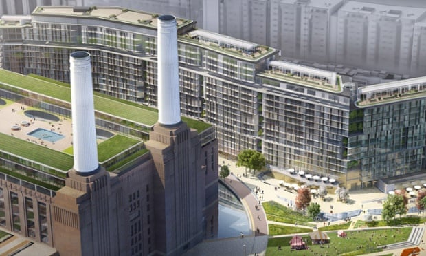
Despite multiple objections from politicians and notwithstanding Boris Johnson’s 2011 Manifesto for Public Space, the construction of Pops such as More London is continuing to escalate and expand, including nine acres planned in Tower Hamlets, a vast patch outside the Battersea Power Station development, and open space and parks at Woodberry Down near Manor House, where I was chased around for taking photos a few months ago. Given how all these developments seem to contradict stated city authority goals to increase public space that is actually publicly owned, one could be forgiven for thinking that the GLA is not actually in control of development in London.

The proposed redevelopment of Battersea Power Station, which will be a privately owned public space.
The proposed redevelopment of Battersea Power Station will include yet more privately owned public space. Photograph: LDA Design

So what is it we expect to happen in public space? In 2008, geographer Ash Amin wrote that “public spaces marked by the unfettered circulation of bodies [produce] new rhythms from the many relational possibilities”. I experienced elements of this in the Phnom Penh National Stadium. But, when space is controlled, and especially when the public is unclear about what the legal or acceptable boundaries of activity are, we tend to police ourselves, to monitor our behaviour and to limit our interactions, especially after embarrassing confrontations with security.

Property owners are perfectly aware of this and prey on those sensibilities. The new King’s Cross development at Granary Square is one of the largest open-air spaces in Europe – about the same size as Trafalgar Square. Unlike Trafalgar Square, it is also a Pops. Photographer Nicholas Goodden set up a tripod there recently to take a photo, and was immediately asked by security whether he had a permit to do so. When he said he did not, he was ordered to move across the canal to get his image. In other words, he was kicked out of “public” space. This would not have happened to a photojournalist in Trafalgar Square, which is owned by the Crown and managed by the Greater London Authority.

Moreover, an encounter with security like this may make you wary and cause you to confine your behaviour to a narrow range so as to avoid confrontation. The psychological effects of this sort of self-policing were written about by Michel Foucault: “He who is subjected to a field of visibility, and who knows it, assumes responsibility for the constraints of power; he makes them play spontaneously upon himself; he inscribes in himself the power relation in which he simultaneously plays both roles; he becomes the principle of his own subjection.”

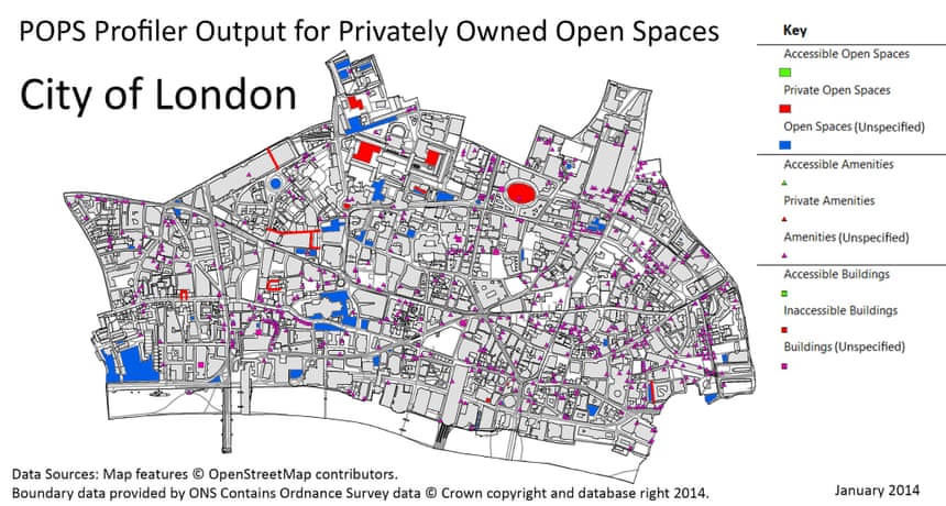
Oliver Dawkins's Pops Profiler.
The Pops Profiler, by Casa student Oliver Dawkins, shows privately owned public space in London’s Square Mile
Geographer Don Mitchell suggests that what public space provides in a city under surveillance are small islands of freedom surrounded by Foucault’s “carceral archipelago” – the surveilled city. Herein lies a crucial question: what happens when our small islands of freedom become indistinguishable from the rest of the city? Sociologist Richard Sennett suggests that private public spaces are “dead public spaces” because the essence of conviviality, spontaneity, encounter and yes, that little sprinkle of chaos, have been stripped out. The spaces are not rendered dead because they aren’t enjoyable – I myself enjoy lounging on the steps near the canal at Granary Square – but dead because the potential range of spatial engagement here can fit in a coffee cup.

“By claiming space in public, by creating public spaces, social groups themselves become public,” Mitchell writes. “Only in public spaces can the homeless, for example, represent themselves as a legitimate part of ‘the public’.” I’m sure we can all imagine how Granary Square security might respond to a homeless Londoner making their woes public on their private AstroTurf.

The power for corporate entities to not only impede certain activities but to bar the public access to “public” space was upheld during the Occupy protest court proceedings. On 14 October 2011, an injunction passed “preventing ‘persons unknown’ entering or remaining in or trespassing on [Paternoster Square]”. While Occupy may seem like ancient history, these proceedings were important because they set a precedent: protest would not be tolerated in open-air private space.

It is no coincidence that the aforementioned Lexicon lurker deployed a tent in his bogus ad. The tent has become a powerful totem: from Brian Haw to Occupy, it symbolizes the bringing of the domestic sphere into the public, and has become so feared by authorities that Westminster City Council passed bylaws in 2012 “to regulate tents and other structures and sleeping equipment”. So much for urban camping

At a recent TEDx Southampton University event about public space in London, I suggested that the moment for direct action against the loss of public space is upon us – an action that would echo the mass trespass of Kinder Scout by the Rambler’s Association in 1932, described by Lord Roy Hattersley as “the most successful direct action in British history”. Taking action by finding and using public space sidesteps the thorny, and frankly depressing, issue of what has been lost. Instead, it focuses on what we can do.

The first hurdle, however, is that public space in London has not been mapped in any sort of systematic way. Oliver Dawkins, doing degree work at UCL’s Centre for Advanced Spatial Analysis (Casa), created a “Pops Profiler” that enables us to see how this plays out in the Square Mile. Publicly available data on Open Street Maps (OSM) do not indicate a single open space that is explicitly designated as publicly accessible (though there are many where ownership is “unspecified”). This suggests that OSM users can’t tell which open spaces are public and which are private.

Last year, when I tried to walk a section of the Thames Path with Jack Shenker and Anna Minton, we found many underutilised parts of the trail – including one that a building security guard asked for identification to access. Hostile architecture intimidates people away from access, poor signage misdirects them. What I suggest in my TEDx talk is that we should start systematically mapping out and using these public spaces to raise awareness about what we have – before we lose it.

So that’s my plan. Along the way, in a series of articles for Guardian Cities, I intend to tackle overarching questions about where public spaces are, and what they are for. I am also interested in the ways that people subvert private space by undertaking “public” acts without permission, to create what Hakim Bey calls “temporary autonomous zones”. The deployment of the tent on Lexicon Tower is a good example of that.

As an ethnographer, I am keen to approach this project from the ground up, seeking out small acts and helping to organised events in public spaces. The fundamental question for me is one of visibility. If information about public space – where it is, what we can do in it – is not clear, then small acts can reveal what is and is not possible ... which we can then map. If you have a story you would like to share for inclusion in future pieces, please do get in touch.

http://www.theguardian.com/cities/2015/aug/04/pops-privately-owned-public-space-cities-direct-action

Tuesday, December 15, 2015

Let’s Stop Letting Starchitects Ruin College Campuses


At some point, things began to fall apart in planning campuses.” – James Howard Kunstler


College tuition has been on the rise for forty years, with no signs of leveling off. This means that more students are graduating with loans, and a lot of them — in 2013, 70% left school in debt, with an average owed amount of $28,000. But rather than cutting costs, colleges are spending more and more money on their exterior aesthetics. This practice is part of what Washington Monthly calls the “prestige racket,” in which universities hire big-name architects to design “upscale” campus buildings in an attempt to attract students.

One of the boldest examples comes from the University of Cincinnati, which has enlisted a “murderers’ row” of architects to redesign their campus, including Frank Gehry, Michael Graves, Peter Eisenman, Bernard Tschumi, and Thom Mayne. This adds up to a lot of shiny new buildings, including the crown jewel – Mr. Mayne’s exorbitant $112.9 million Campus Recreation Center, which opened in 2006. But there’s even more in the works: UC’s Department of Athletics has requested a $70 million renovation of the basketball arena, which, if approved, will open in 2017.

The Campus Recreation Center, a monument to rising tuition | Image from Richie Diesterheft via flickr

To support all of this construction, the college has taken on a massive debt load, currently around $1.1 billion. The school has also experienced dramatic spikes in tuition, while its professors earn salaries that rank far below those at similar research institutions. As more and more of that money goes to debt service, students take the hit. The average UC student leaves with $23,000 in debt, and that number could be closer to $30,000 for those on the more expensive (and flashy) main campus. And as they are taking on more and more debt, they are receiving less and less from the school itself. According to The College Fix, between 2005 and 2013, academic spending per full-time undergraduate student at UC dropped 24 percent.

Once the architect leaves, the academic community is left to deal with the fallout of buildings that don’t just  ignore their surrounding contexts, but also frequently overlook basic construction principles. Notably, MIT sued Frank Gehry when his $300 million Stata Center made headlines not for its eye-catching deconstructivist design but for the “pervasive leaks, cracks and drainage problems that have required costly repairs.”


The Stata Center is attractive from afar, but offers little at the ground level. | Image from Nathan Rupert via flickr


Gehry isn’t the only “starchitect” guilty of construction problems: At Cornell University, one architecture professor has taken it upon himself to document continuing structural issues in Rem Koolhaus’s Milstein Hall, which has “egregious code violations.” Indeed, Cornell has had a string of bad luck with big-name architects, suing I.M. Pei for “architectural malpractice” that led to “structural deficiencies, roof cavities, ceiling cracks and other flaws” at the Johnson Museum of Art.

Down south, Florida Polytechnic dropped $60 million on a new Innovation, Science, and Technology building designed by Santiago Calatrava, who is as famous for his budget overruns as he is for the quality of his architecture. That project made Slate’s “11 Worst Buildings of 2014” list for violating “possibly every tenet of good planning and design in 2014.”

The back of the PPS office gives a fine view of the irregular geometry that defines the Thom Mayne-designed Cooper Union academic building, which was completed in 2009. Although lauded by the critical establishment for its “bold, aggressive profile,” it has received criticism from every other angle for driving the school into debt, so much so that it had to start charging tuition for the first time in its 150-year history. (Funds for the $166 million building did not come from donors, but rather through a mortgage, at a 6% interest rate.) Taking up an entire city block, the structure breaks up the neighborhood with its massive concrete supports and a series of surrounding (and uncomfortable) benches. The building’s street level is abysmal –  clearly an afterthought for an architect far more concerned with how his buildings will be received from afar. Paying no attention to the “architecture of place,” the building is situated uncomfortably amidst historic East Village landmarks. A fitting symbol, perhaps, of a neighborhood that is being gradually erased through over development and gentrification.

The building that caused Cooper Union to start charging tuition for the first time ever | Image from Steve Silverman via flickr


Cooper Union is already one of the most selective undergraduate institutions in the world, so they certainly didn’t need to make a grand statement in order to attract more students. Both the school and the community would have been better served had the institution spared some of the $166 million they spent on the building and erected a simpler structure. There are a lot of losers here: the students who must now pay tuition; the institution’s founder Peter Cooper, whose philosophy that education should be “open and free to all” has been compromised; and PPS employees who have to look at the damn thing every day. But the biggest loser is the surrounding community, who have lost a key link in their place network. The building stands as a tangible marker of this loss, and hopefully as a warning call to other institutions who still believe that a big-name architect is a valuable investment.

It’s time to start thinking of our campuses as places


Where do we think universities should spend their money instead? As former PPS staff member Phil Myrick has written: “Billions of dollars go into building facilities that hide their assets behind blank walls. If a tiny part of the investment was directed to bringing the building program to the outside, it would make a vast difference on people’s experience of the campus.”

Universities need not cease new construction altogether, but students, faculty, staff, and administration would all be better off if new buildings were required to be integrated into a larger conception of the campus as a public commons (in light of ongoing anti-racism protests on campuses, it is more important than ever to ensure that public spaces are available to foster debate). The first step in creating this vision is a placemaking plan, created with all of the stakeholders (students, faculty, staff, administration, the community) to determine how the campus’s built environment can best serve everyone. This input can then be organized into a public space master plan for the campus, which can dictate how buildings interact with the spaces around them.

“Campuses need to be thought about in terms of destinations, how the various buildings relate, where the gathering places go, where you want walkways–and then fit the streets to that vision. In most cases this will result in a total rethinking of each street’s design.” – Phil Myrick

A great example of a campus that is building itself around its common spaces is Harvard University, where PPS has worked for the past ten years on various projects. In 2008, the university established a “Steering-Committee on Common Spaces” to drive new activity and life to under-utilized sections of campus. “Imagine places where classroom conversations and debates are continued informally, places where serendipity leads to discovery” said committee member Evelynn Hammonds, describing the space. “This kind of community interaction holds great promise.”

A much better use of precious dollars than a new Gehry building | Photo courtesy Harvard Campus Services


The program at Harvard has been a resounding success, especially in “The Plaza,” a one-time “pass-through” route that has been turned into a thriving destination. It has become a lab for experimentation, hosting at various points a skating rink, markets, fire pits, a “Plaza Pet Therapy Zoo,” and much more. The program shows what is possible when a university dedicates itself to building its campus around places, and institutions everywhere should be taking notes.

Many institutions of higher education have a limited pool of funds, and when they spend unwisely the entire academic community suffers. Students pay higher tuition, faculty members are paid less, and the residents of surrounding neighborhoods lose a potential gathering space. But more than this, universities don’t need expensive buildings to attract students. Potential students visiting the school likely won’t remember the buildings themselves, they will remember the quality of its public spaces and how people were interacting in and around them.

Campuses that encourage sociability through an architecture of place will come out on top, and save money to boot. It’s time to scale back on pretentious starchitect-designed campus buildings and start spending more time thinking about the role of the university itself, and the the public spaces therein, to nurture the social, intellectual, and cultural life of our students and future leaders.

http://www.pps.org/blog/starchitects-and-campuses/?mc_cid=588634ee96&mc_eid=70f2815b12


Thursday, September 25, 2014

What a Park’s Design Does to Your Brain


AP Photo/Julie Jacobson
 As a student in Poland, Agnieszka Anna Olszewska was fascinated by the way that some landscapes seemed to be more contemplative than others. She wanted to research the reasons behind that calming effect, but she found little encouragement. “People told me I can write a novel, I can write a poem about the contemplativeness of landscape, but not a scientific paper.” One well-respected landscape architect told her it couldn’t be done because of the diversity of human responses: Some of us might find a garden conducive to contemplation; others might prefer the bathroom.
But Olszewska, now a doctoral candidate in landscape architecture and urban ecology at the University of Porto in Portugal, persevered. With a neuroscience professor at the university, she conducted a pilot project that culminated, earlier this year, in a conference paper titled “Urban Planning, Neurosciences and Contemplation for Improving Well-being in Our Cities.” It combined questionnaire results with measurement of brain waves in an effort “to prove that there are certain characteristics of urban parks and gardens that can induce in the visitor the pattern of brain activity that is associated with contemplative or meditative states.”

We know that cities can be hectic, stressful places. We also know that green space can have a calming effect on people. But Olszewska is seeking to take our knowledge a step further — to enable designers and planners to maximize the serenity of urban green refuges.

In the study, four design experts examined 50 photographs from three urban parks in Portugal and France. The experts were also given a checklist of design features (such as long-distance views, biodiversity, “canopied,” “panoramic”). They identified which features appeared in each photograph, and also evaluated each setting’s contemplativeness. The settings deemed most contemplative had panoramic vistas with long-distance views (more than 400 meters). They tended to include large empty spaces, natural asymmetry, clearings and stimulation to look at the sky. The least contemplative settings, by contrast, usually lacked these features, and instead had characteristics such as paths and enclosed spaces (as in small pocket gardens).

In the second part of the project, subjects were asked to look at the 15 photos of landscapes ranked highest by the experts for contemplativeness. Their brain waves were recorded by electroencephalography (EEG) during this task. The brain activity, Olszewska said, was similar to patterns known to be associated with mindfulness achieved through meditation. She stresses, though, that her research is quite preliminary; subjects weren’t shown the least contemplative spaces. (She is currently working on a study that includes this kind of control group.)

The most contemplative landscapes are not necessarily the ones that people would claim to enjoy the most. More stimulating landscapes — brightly colored flowers, numerous eye-catching elements — may be more immediately attractive. “If you imagine the French baroque gardens, they are very geometrical, very organized,” said Olszewska. But this kind of environment, however beautiful, may be less relaxing to spend time in.

This is not to say that the opposite extreme — wild landscapes — are necessarily more contemplative. Olszewska thinks we tend to find those overwhelming. Instead, she hypothesizes that the ideal is a “golden middle” between too much design and too little.

The small experiment is part of a larger, nascent movement to try to connect neuroscience to architecture and design. The movement for “evidence-based design” originated in the health care field. One famous finding was that in hospitals — historically not the most pleasant places — surgical patients whose windows faced natural outdoor scenery were discharged sooner and requested fewer painkillers than patients whose windows faced a brick wall. Inspired by this movement, others began to think that there was no reason to limit such thinking to hospitals. It spread to schools, and now, increasingly, the built environment and urban green spaces. Some researchers began to incorporate neuroscience. Much of the interest is focused on contemplativeness. Perhaps, just as hospitals need healing spaces, cities need serene oases to counteract the urban chaos.

Julio Bermudez, an associate professor of architecture and planning at the Catholic University of America, studies how the built environment can induce states of relaxation and mindfulness. In one study, which he presented last week at the second annual conference of the Academy of Neuroscience for Architecture, architects looked at photographs of buildings designed to be contemplative, including the Salk Institute in San Diego and the Pantheon in Rome, as well as ordinary buildings. The contemplative buildings reportedly elicited “markedly distinct” responses, as measured by functional Magnetic Resonance Imaging (fMRI). Bermudez and his co-authors (including a neuroscientist at the University of Utah) concluded that contemplative buildings “allow subjects to enter into a meditative state with diminishing levels of anxiety and mind wandering.”

In an email, Bermudez speculated about some common features of contemplative design: buildings that frame nature in some way; that exhibit simplicity without being simplistic; and that offer a sense of separation from the rest of their context, among other qualities. Some “remarkable cities,” he wrote, “naturally invite contemplative states.” As examples, he cited Santiago de Compostela in Spain and Bodh Gaya in India, as well as parts of Paris, Washington D.C. and San Francisco.

It may be true that, as the landscape architect warned Olszewska, it’s hard to make blanket generalizations about what people find contemplative, and responses may vary culturally too. It’s also notoriously challenging to interpret brain waves conclusively, and this research is in its infancy. But both Olszewska and Bermudez believe there are certain common features that can broadly foster these meditative responses. And rather than write poems, they hope to prove it with the tools of fMRI and EEG.

The Science of Cities column is made possible with the support of the John D. and Catherine T. MacArthur Foundation.

Rebecca Tuhus-Dubrow is a columnist for Next City. She has also written for the New York Times, Slate and Dissent, among other publications.

 http://nextcity.org/daily/entry/city-parks-design-calming-brain

Friday, September 5, 2014

Three Perspectives on Designing Resilient Cities


Hurricane Sandy has changed the national conversation on climate change. Unlike Hurricane Katrina, which much of the country was happy to pin the blame for on New Orleans itself (“they shouldn’t have built there in the first place!”), Sandy revealed climate change to be a growing threat to nearly all coastal settlements. Formerly abstract warnings of growing inundation risk, stemming from rising sea levels and increasing storm frequency, suddenly became concrete and impossible to ignore. A new found sense of vulnerability descended on coastal cities. In this light, urban design cannot be dismissed as merely a luxury or an aesthetic consideration. The discipline has taken on a new relevance and sense of urgency: cities, particularly in coastal settings, must reconsider their built form in order to adapt to radically altered environmental conditions. Three new books by Island Press approach these issues with renewed sense of the value of the urban design.
Entertaining and attractively designed, Alexandros Washburn’s The Nature of Urban Design: A New York Perspective on Resilience provides a fantastic introduction to the discipline of urban design for non-designers. Washburn, the chief urban designer for New York City, uses that city as case studies to explain what exactly urban designers do and why it matters. He broadly defines urban design as “the art of changing cities, guiding growth to follow new patterns that better meet our challenges while improving our quality of life.” Of course, perhaps the biggest challenge facing cities today is climate change, and The Nature of Urban Design uses Hurricane Sandy to illustrate the need for adaptation, and how urban design can act as an agent of change.

Washburn includes the suburbs in his definition of the city, stating that the suburbs simply represent low-density cities, thus breaking down the false city/suburb dichotomy. Washburn’s inclusion of the suburbs is important because it allows him to expand the purview of urban design beyond the city center to the entire metropolitan area. Urban design isn’t about recreating a single notion of what the city is, but instead about adaptation and improving living conditions, regardless of location within the metropolitan region. Instead of seeking a rigid urban design toolkit, Washburn asks, “Is there a form of the city that can survive new extremes of weather, that can accommodate millions more citizens in dignity and prosperity, that can avoid contributing more to climate change, and still be worth living in?”
He methodically walks us through why urban design matters, how urban designers work, how urban design can be a catalyst for transformation (using the High Line as a case study), and how it can lead to resilience in the face of climate change. He discusses two strategies for resilience: mitigation and adaptation. Mitigation means reducing greenhouse gases in order to prevent adverse climate change, while adaptation involves reducing vulnerability to projected climate change. With a certain degree of environmental change now inevitable and a dramatic, global reduction in greenhouse gas production seeming less and less likely, Washburn’s approach to resiliency is both idealistic and practical.

Like Washburn’s book, The Hidden Potential of Sustainable Neighborhoods: Lessons from Low-Carbon Communities, by Harrison Fraker, uses global climate change to frame the new importance of urban design. Unlike Washburn’s broad overview of the profession, however, Fraker’s is more narrowly focused, using four European case studies to dig into the specifics of several low-carbon urban design projects. Fraker describes how sustainability issues such as energy efficiency have historically only been considered on the building scale. The neighborhood scale, however, represents new opportunities for carbon reduction. Fraker argues that the neighborhood scale has the “potential to integrate the design of transportation, buildings, and infrastructure while engaging the design of the public realm as part of the system.” He refers to this as a “whole-systems approach,” where all urban systems are considered together, greatly expanding the potential for resiliency.

 The Hidden Potential of Sustainable Neighborhoods is about mitigation, citing examples of low-carbon urban design projects. This does not mean, however, that Fraker is merely presenting a series of utopian designs. Each of the examples in the book is actually built, and Fraker looks back at commonalities between each project’s implementation and subsequent performance. Furthermore, he applies the lessons learned from the four European examples to sprawling, patchwork American urbanism, describing the potential for infill opportunities. Fraker could have spent more time addressing how to retrofit existing development rather than concentrating on new development. Still, as he states, new models can catalyze paradigm shifts, and we should appreciate his effort to translate European lessons to messy American cities.

If The Nature of Urban Design is a layperson’s introduction to urban design, and The Hidden Potential of Sustainable Neighborhoods is a case-study resource for urban designers, The Guide to Greening Cities, by Sadhu Aufochs Johnston, Steven S. Nicholas, and Julia Parzen, is probably of most interest to urban planners. Like the other two books, The Guide to Greening Cities lays out the challenge of designing cities in the face of climate change. Johnston and his co-authors also refer to Hurricane Sandy, as well as other climactic events, to establish the new urgency of resilient city design.

 Instead of studying the design of resilient cities, however, Greening Cities explores how city leaders can implement new sustainability projects. Johnston and team state that the book is “written from the perspective of green city leaders and champions who are working inside city governments in North America and who have succeeded in pushing forward innovative green projects.” Rather than emphasizing the design of sustainability, Greening Cities walks through how city leaders can make a case for, fund, implement, and subsequently monitor green projects. In this way, The Guide to Greening Cities is a useful book for urban planners wishing to increase the resiliency of their communities.
Cities are now faced with the task of both adapting to inevitably changing environmental conditions and minimizing their contributions to future climate change. The political, economic, environmental, and technological challenges associated with this task are bewilderingly complex. However, recent events such as Hurricane Sandy have shown inaction to be an increasingly tragic prospect.

The complexity of designing for urban resilience requires a broad cultural shift across many different disciplines. These three books address the same problem of designing in the face of global climate change, but do so for different audiences – the general public, urban designers, and urban planners. With the consequences of global warming no longer abstract, hopefully the sense of urgency that inspired these books will not abate.